Portfolio
Equus Energy
BACKGROUND
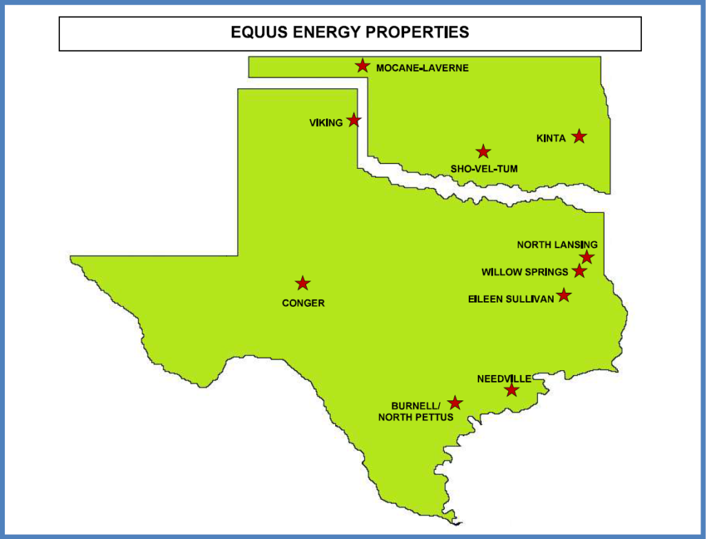
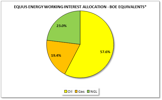
Equus Energy, LLC (“Equus Energy”) has non-operated ownership of 10 fields in Texas and Oklahoma (collectively, the “Properties”). This portfolio represents interests in 141 wells across 13 counties in these two states. Proved reserves are 44% producing and approximately 58% oil; additional liquids are associated with the gas reserves which have a high BTU content. A significant portion of the overall value stems from the Company’s 2,400 acres in the Conger Field. Located in Sterling County, Texas, the Conger Field is operated by Chevron and has historically managed an active recompletion program.
FIELD LOCATIONS
The Company’s 10 field locations range from the Texas and Oklahoma panhandles to the Gulf Coast. Two of these fields, the Conger and the Burnell/North Pettus fields, have rights to the Permian Wolfcamp formation and the Eagle Ford formation, respectively, two of the most productive and low cost hydrocarbon production zones on earth.
CONGER ACREAGE DESCRIPTION
Lease Name | Land Description | Gross Acres |
V.E. Brownfield | All of Section 48, A-940, Blk 32, T5S, T&P RR Co. Survey, Sterling County, Texas; Rights from the surface to the base of the Pennsylvanian Pay Zone | 640 |
Cope Andrews Unit 1 | 90 acres of land situated in the southwest corner of Survey 2, Blk 2, EL&RR Co. Survey, A-1051, Sterling County, Texas; Rights from the surface to the base of the Pennsylvanian Pay Zone | 90 |
Cope Seale Unit 1 | Rectangular tract of 90 acres; Rights from the surface to the base of the Pennsylvanian Pay Zone | 90 |
EB Cope 1-16 | All of Section 1, Blk 2, A-52, EL&RR Co. Survey, Sterling County, Texas; Rights from the surface to the base of the Pennsylvanian Pay Zone | 640 |
EB Cope B1-4, 1-5 | 460 acres in Section 2, Blk 2, EL&RR Co. Survey, Sterling County, Texas. | 460 |
PT Mahaffey | NW/4 of Section 10, Blk 2, T&P RR Co. Survey, A-1167 and A-1084, Sterling County, Texas; Rights from the surface to the base of the Pennsylvanian Pay Zone | 160 |
Sterling S Fee | N/2 of Section 25, Blk 2, T&P RR Co. Survey; Rights from the surface to the base of the Pennsylvanian formation | 320 |
TOTAL: | 2,400 |
CONGER HISTORY
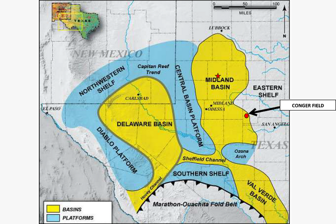
Equus Energy holds a 50% working interest in 40 Canyon Sand gas wells and rights to 2,400 gross acres in the Conger Field, located in Sterling County, Texas. The Conger Field is situated on the eastern (termed the “Midland”) side of the Permian Basin, the largest petroleum producing reservoir in the United States measured both by reserves and production, which presently accounts for almost ¼ of aggregate U.S. hydrocarbon production.
Equus Energy’s Conger wells are operated by Chevron USA, which has drilled over 350 Canyon Sand wells in the Conger Field since 1975. The wells were initially reported as oil wells (on a lease basis) then gradually reclassified as gas wells. In 2003, Chevron began a recompletion program in an oil and gas field near Conger from the Canyon Sand reservoir (upper Pennsylvanian formation) to the Wolfcamp formation, a prolific producer of oil and natural gas throughout the Permian Basin. In November 2016, the U.S. Geological Survey estimated that 20 million barrels of oil, 1.6 billion barrels of natural gas liquids, and 16 trillion cubic feet of natural gas was recoverable from the Wolfcamp formation.
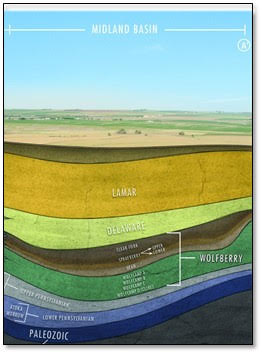
Below is an illustration of the various geologic strata in the Midland section of the Permian Basin, with the Wolfcamp formation (divided into 4 sub-zones) beginning at a depth of approximately 6,000 feet.
In just the past three years, increasing efficiencies gained from horizontal drilling techniques, including longer lateral drilling, use of Northern White Wisconsin sand to create higher porosity, and increased proppant and fluid intensity have resulted in a 30% increase in initial production rates and a 106% increase in ultimate recovery rates.
CONGER WELL MAP
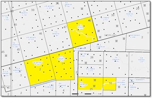
The Conger Field is located in the southwestern corner of Sterling County, Texas, with the various Conger leases situated on contiguous or adjacent township sections concentrated in a few square miles. The leases in which Equus Energy holds a working interest are highlighted in yellow below:
BURNELL/N. PETTUS ACREAGE DESCRIPTION
Unit Name | Land Description | Gross Acres |
Burnell Unit | Unitized May 28, 1947 | 7,233 |
North Pettus Unit | Unitized May 28, 1947 | 6,327 |
TOTAL: | 13,560 |
BURNELL/N. PETTUS HISTORY
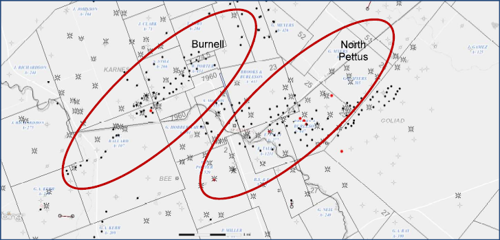
Generally. Equus Energy holds a 7.2% working interest in the Burnell Field and a 2.5% working interest in the North Pettus Field located in Karnes, Bee, and Goliad Counties in Southeast Texas. These interests have been unitized through various limited partnership and joint venture structures, with Trinity River as the principal operator, having acquired its operating interest from Legend Natural Gas LP in 2017. Legend acquired operatorship from Devon in 2005 and has since drilled over 20 wells in the two fields. The main targets have been the Middle Wilcox Z and G Sands at depths of 9,000’ and 10,000’. On the Burnell and North Pettus Units, there are 69 total wells that collectively produce approximately 2,000 MMCFD and ~200 barrels of liquids per day.
Burnell. The Burnell Field, also known as the Burnell Unit, is located just north of the North Pettus Unit of the Tulsita-Wilcox field. They are very similar accumulations with the trap being a downthrown structural closure that produces from the same Upper and Middle Wilcox Sands. Like the North Pettus Unit, Burnell Field was a Pennzoil legacy field. Prior to the sale of its interest in 2017, Legend drilled five wells in the Burnell Unit since 2005 and has made three Middle Wilcox Z or G Sand completions, one Upper Wilcox Massive Sand completion and one Upper Wilcox Slick Sand completion.
North Pettus. The Tulsita-Wilcox Field was discovered in 1942 by Union Producing Company, and the majority of the field was unitized in 1947 as the North Pettus Unit. Prior to the sale of its interest to Trinity River in 2017, Legend drilled 17 wells in the unit since beginning their initial drilling program in early 2006. This activity resulted in an increase in gas production from 2,600 MCFD to over 18,000 MCFD in 2008. The Upper and Middle Wilcox Sand reservoirs are encountered at drilling depths of 6.000’ to 10,000’. The primary trap at all levels is a simple, downthrown rollover structural closure. The Middle Wilcox Sands, which are encountered at depths from 9,000’ to 10,000’, have been the primary focus of legend’s drilling program. Thirteen out of the 17 wells drilled at North Pettus Unit are Middle Wilcox Z or G Sand completions.
BURNELL/N. PETTUS WELL MAP
